1747 Bowen Map of Northern Italy with a Nautical Chart of Livorno 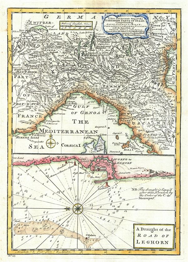 WE SELL ONLY ORIGINAL ANTIQUE MAPS - NOT REPRODUCTIONS Title: A New and Accurate Map of the Northern Parts of Italy. A Draught of the Road of Leghorn. Description: This is a beautiful map of northern Italy, issued in 1747 by the British cartographer Emanuel Bowen. Essentially two maps on a single sheet, the upper map covers northern Italy from Lake Geneva in Switzerland to the Island of Elba. It includes Savoy, Piemont, Milan, Parma, Mantua, Modena, Tuscany and the republics of Venice, Genoa and Lucca. Several important towns, cities, roads, rivers, and other topographic features are noted, with mountains rendered in profile. The lower map features a nautical chart of Leghorn or Livorno. Oriented to the west, this chart notes coastal cities and towns in detail showing streets and buildings in profile. Rhumb lines and soundings are present throughout. A note reads, This draught is copyd after that drawn by the Order of the C: de Maurepas. This map was prepares by Emanuel Bowen as plate no. 23 for the 1747 issue of A Complete System of Geography. Size: Printed area measures 13.5 inches high by 9.5 inches wide. Condition: Very good. Original platemark visible. Minor damp stain in top margin, not extending onto printed area. Blank on verso. Shipping: Shipping rates are not negotiable. Items are shipped within three business days of receiving payment. We are happy to consolidate shipping where possible. The following shipping options are available: 1. FedEx Overnight (45 USD). USA Only. Signature Required. Customs: International buyers are responsible for paying duty and taxes on delivery. DHL or FedEx will contact the buyer by telephone to arrange tax payment if it is levied. Duty varies by country and we cannot predict the amount you will be charged. Some countries are duty free, others are not. Typically, a customs duty and/or VAT tax will be assessed on all parcels to continental Europe. Sometimes duty or tax is due in China, but is seems very random. Hong Kong, Singapore, Korea, and Taiwan have never assessed duty on a map we shipped. Maps shipped to the UK should be duty free as educational materials, but from time to time duty of 5% is assessed incorrectly by the UK customs agents. Insurance: All shipments are insured privately against loss and damage. All of our shipments require a signature for insurance purposes. If you have any questions please feel free to email us through eBay. Other Services Conservation Framing: Geographicus recommends basic conservation framing services for any antique paper. We do not offer this service. |

1747 Bowen Map of Northern Italy with a Nautical Chart of Livorno WE SELL ONLY ORIGINAL ANTIQUE MAPS - NOT REPRODUCTIONS Title: A New and Accurate Map of the Northern Parts of Italy. A Draught of the Road of Leghorn. Description: This is a beautiful map of northern Italy, issued in 1747 by the British cartographer Emanuel Bowen. Essentially two maps on a single sheet, the upper map covers northern Italy from Lake Geneva in Switzerland to the Island of Elba. It includes Savoy, Piemont, Milan, Parma, Mantua, Modena, Tuscany and the republics of Venice, Genoa and Lucca. Several important towns, cities, roads, rivers, and other topographic features are noted, with mountains rendered in profile. The lower map features a nautical chart of Leghorn or Livorno. Oriented to the west, this chart notes coastal cities and towns in detail showing streets and buildings in profile. Rhumb lines and soundings are present throughout. A note reads, This draught is copyd after that drawn by the Order of the C: de Maurepas. This map was prepares by Emanuel Bowen as plate no. 23 for the 1747 issue of A Complete System of Geography. Size: Printed area measures 13.5 inches high by 9.5 inches wide. Condition: Very good. Original platemark visible. Minor damp stain in top margin, not extending onto printed area. Blank on verso. Shipping: Shipping rates are not negotiable. Items are shipped within three business days of receiving payment. We are happy to consolidate shipping where possible. The following shipping options are available: 1. FedEx Overnight (45 USD). USA Only. Signature Required. Customs: International buyers are responsible for paying duty and taxes on delivery. DHL or FedEx will contact the buyer by telephone to arrange tax payment if it is levied. Duty varies by country and we cannot predict the amount you will be charged. Some countries are duty free, others are not. Typically, a customs duty and/or VAT tax will be assessed on all parcels to continental Europe. Sometimes duty or tax is due in China, but is seems very random. Hong Kong, Singapore, Korea, and Taiwan have never assessed duty on a map we shipped. Maps shipped to the UK should be duty free as educational materials, but from time to time duty of 5% is assessed incorrectly by the UK customs agents. Insurance: All shipments are insured privately against loss and damage. All of our shipments require a signature for insurance purposes. If you have any questions please feel free to email us through eBay. Other Services Conservation Framing: Geographicus recommends basic conservation framing services for any antique paper. We do not offer this service. |

